The Ultimate Explorer’s Guide to Hiking at Spencer Gorge Conservation Area to Dundas Peak
Mastering Your Outbound Excursion to Spencer Gorge Conservation Area
Planning an unforgettable afternoon of hiking in Ontario requires a deep understanding of local park management policies and route structures. Spencer Gorge Conservation Area is renowned for its steep drop-offs, historic significance, and sensitive ecosystems. It is highly recommended that visitors review current operational guidelines prior to departing from home.
          [Tew Falls Parking Lot / Harvest Rd]
                           │
                           ▼
                  [Tew Falls Lookout]
             (41-Metre Ribbon Waterfall)
                           │
                           ▼
           [Tew Falls to Dundas Peak Walk]
         (1.8 km Loop / Bruce Trail Sides)
                           │
                           ▼
                 [Dundas Peak Lookout]
           (Panoramic Dundas Valley Views)
Navigating the Ancient Geography of the Spencer Gorge
The physical features which have made the Niagara Escarpment one of Ontario’s most spectacular geological formations are exhibited beautifully within this protected zone. Millions of years of glacial activity and aquatic erosion are represented by the deeply carved limestone valley. From the high escarpment brow, noted for its panoramas, to the forested depths of the gorge below, an incredible variety of microclimates is hosted by the terrain.
Rare plant species are sheltered by the unique topography of the canyon, making off-trail exploration highly destructive. This significant natural area contains two beautiful waterfalls: Webster and Tew Falls. Visitors are continuously captivated by how seamlessly the rolling Carolinian forests blend into sheer vertical rock faces.
Understanding the Waterfall Systems
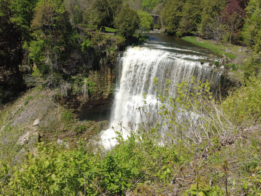
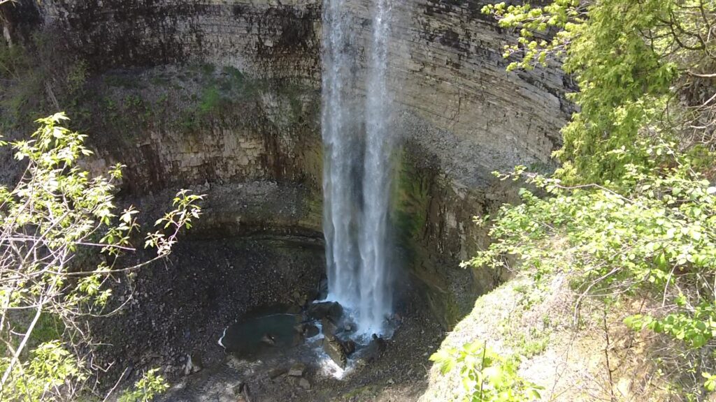
Two distinct hydrological marvels are situated within the boundaries of the park, each offering a completely different visual experience. Webster is a magnificent tiered waterfall that spans a wide crest, whereas Tew Falls towers at a staggering 41 metres. Interestingly, Tew Falls is only a few metres shorter than Niagara Falls, making it an incredibly imposing sight during the spring melt.
Spectacular vistas of the gorge are offered by both vantage points, allowing photographers to capture the raw power of natural erosion. The water that plummets over these ledges is fed by Logie’s Creek and Spencer Creek, eventually snaking its way toward Lake Ontario.
Dundas Peak: Capturing the Most Spectacular Panoramic Vistas in Ontario At Spencer Gorge Conservation Area
The Essential Trail Summary Highlights a Breathtaking 110-Metre Escarpment Overlook Above the Historic Town of Dundas.
The journey toward the most famous cliffside overlook in the Hamilton region is characterized by rolling singletrack trails and sections of exposed limestone. The Tew Falls to Dundas Peak walk is a moderately challenging route that measures approximately 1.8 kilometres for the main loop.
                                      ___
                                    /     \
                                   |       |  <-- Dundas Peak Lookouts
                                    \___  /      (110m Elevation Drop)
                                        │
                                        │
    [Forested Gorge Slopes]  ◄──────────┼──────────►  [Fenced Boundary Trails]
    (Unstable Limestone)                │             (Stay On Marked Paths)
                                        │
                                        ▼
                             [Tew Falls Connection]
Steps for a Safe Hike At Spencer Gorge Conservation Area
- Equip proper footwear: Sturdy hiking boots with deep lugged soles should be worn to maintain traction on loose gravel and slippery mud sections.
- Locate the trailhead safely: Access to the path is positioned immediately adjacent to the primary automated parking area off Harvest Road.
- Monitor directional trail arrows: The main loop must be traversed in a clockwise direction as mandated by park safety personnel to manage pedestrian traffic.
- Maintain a safe distance from ledges: A distance of at least one full body length must be maintained from any unfenced cliff edges.
Critical Safety Regulations and Cliffside Border Management
The safety of hikers is prioritized by the Hamilton Conservation Authority through the installation of extensive infrastructure. Unfortunately, numerous rescue operations have been triggered in the past by reckless trail behavior.
┌────────────────────────────────────────────────────────┐
│                   SAFETY WARNING                       │
├────────────────────────────────────────────────────────┤
│ • NO ACCESS to the bottom of the falls or gorge area.  │
│ • All former lower gorge trails are CLOSED.             │
│ • Stay at least ONE BODY LENGTH back from the edge.    │
│ • Violators face a $250 municipal parking/trespass fine.│
└────────────────────────────────────────────────────────┘
Strictly Enforced Trail Closures
It must be explicitly understood by all wilderness visitors that there is NO access available to the bottom of the falls and gorge area. All former trails leading into the depths of the canyon are closed and not maintained by park staff. The fragile shale layers beneath the limestone upper crust are easily dislodged, meaning that structural collapses are a constant threat.
Trespassing into these restricted zones is punishable by steep municipal fines, and video surveillance is utilized to monitor problem areas. Attempting to scramble down the rock face is considered an extreme hazard that risks the lives of emergency first responders.
The Purpose of Safety Fencing
Areas in the Spencer Gorge Conservation Area that are fenced off and closed to the public exist for vital liability and conservation reasons. This safety fencing must never be climbed or otherwise bypassed by visitors looking for unique photography angles. The slopes and edges of the escarpment can be unstable and pose a severe fall hazard to anyone standing nearby.
[ Safe Trail Area ] ──► │ Barrier Fencing │ ──► [ UNSTABLE EDGE HAZARD ]
Soil compaction caused by illegal foot traffic destroys the root systems of ancient cedar trees that cling to the rock faces. These trees serve as natural anchors for the cliffside, meaning their destruction accelerates the rate of dangerous rockfalls.
Protecting Vulnerable Visitors and Animals
Keeping well back from the edge of the gorge and escarpment areas, at least a body length, is required by all individuals. Children and pets should be kept well away from these unmonitored zones by responsible adults at all times. Dogs must be secured on a sturdy leash that does not exceed two metres in length to prevent accidental slips over the rocky precipices. Sudden gusts of wind are frequently encountered along the brow of the escarpment, which can easily cause a loss of balance if an individual stands too close to the drop-off.
Logistics, Parking Fees, and Reservation Updates for 2026
Operational strategies are adjusted regularly by the Hamilton Conservation Authority to balance ecological preservation with public accessibility. It is important to note how logistical requirements have shifted over recent seasons.
| Expense Category | Associated Cost (CAD) | Conditions & Provisions |
| Vehicle & Driver Fee | $16.50 | Mandated for all personal standard automobiles |
| Per Passenger Fee | $5.50 | Applied to every occupant over 5 years of age |
| Walk-in / Cyclist Fee | $5.50 | Charged per individual entering via active transport |
| HCA Membership Pass | Free Entry | Valid for 12 months; covers up to 7 people in one vehicle |
Current 2026 Reservation Policy
A significant update to park management strategies was introduced recently by regional authorities. Reservations are no longer required to visit Dundas Peak, Tew Falls, and Webster Falls during standard operating periods. Entry is processed entirely on a first-come, first-served basis at the gatehouse structures.
However, advanced online bookings are still strictly mandated seven days a week during the peak autumn leaf-viewing season. This seasonal window typically runs from late September until mid-November, when the valley foliage transforms into a sea of vibrant crimson and gold.
Strict Parking Constraints and Fines
[ Harvest Road Precinct ] ──► [ No Parking Zones ] ──► Strict $250 Fine / Tow-Away
Vehicular parking is confined strictly to designated municipal lots, and parking on the shoulders of surrounding rural roads is completely forbidden. Buses are not permitted at all Spencer Gorge parking lots under any circumstances due to the tight turning radii of the access roads.
Special enforcement zones have been established by the City of Hamilton throughout the community of Greensville. Illegal parking in these designated residential zones carries a mandatory $250 fine, and tow trucks are deployed rapidly to clear blocked thoroughfares.
Accessibility Infrastructure
Equal access to these incredible natural landmarks is supported through targeted infrastructure designs within the park. This conservation area features two accessible parking spaces, located specifically in the Webster Falls parking lot at 28 Fallsview Road.
While the rugged singletrack path connecting Tew Falls to the peak is completely unsuitable for wheelchairs, the main viewing platforms near the crest of Webster Falls are designed to be fully wheelchair-accessible.
Maximizing Your Adventure: Seasonal Tips and Essential Gear
[ Spring Hike ]   ──► High water volumes at Tew & Webster Falls.
[ Summer Hike ]   ──► Dense green Carolinian canopy; sun protection required.
[ Autumn Hike ]   ──► Peak foliage displays; mandatory reservations apply.
[ Winter Hike ]   ──► Icy vistas; traction spikes strongly recommended.
[ Early Morning ] ──► Optimal lighting conditions and minimal crowds.
An optimal hiking experience is achieved when proper environmental preparation is combined with an awareness of daily peak times. The atmosphere of the gorge changes dramatically across the four seasons, providing a unique excursion with every visit.
Choosing the Perfect Time to Visit
Crowd mitigation is best achieved by arriving at the park gates early in the morning on weekdays. The late afternoon also provides stunning lighting as the sun sinks lower over the western horizon of the Dundas Valley. Summer visits offer the comfort of a dense green canopy that cools the trails significantly during humid days.
Alternatively, winter hiking reveals a landscape of giant icicles and frozen waterfalls, though trails become exceptionally slick. If a weekend trip during July or August is planned, arriving before 9:00 AM is recommended to secure a parking space before maximum capacity is reached.
Recommended Packing Checklist
- Hydration supplies: At least one litre of fresh water should be carried per person since no treated drinking water sources are available on-site.
- Navigation tools: A downloaded digital offline map of the regional Bruce Trail side routes should be kept on your mobile device.
- Environmental protection: Eco-friendly insect repellent and broad-spectrum sunscreen are highly recommended for the exposed ridge sections.
- Waste management bags: All personal garbage must be packed out to keep the sensitive ecological habitats pristine.
Exploring Nearby Wilderness Corridors and Natural Extensions
[ Spencer Gorge Trails ]
          │
          └──► (Bruce Trail Side Connectors) ──► [ Dundas Valley Conservation Area ]
          │
          └──► (Spencer Creek Systems)      ──► [ Crooks' Hollow Historic Route ]
The adventure does not have to conclude once the main overlooks have been thoroughly explored. The surrounding region is rich with interconnected trail networks that showcase the cultural and natural heritage of Southern Ontario.
Connecting to the Historic Bruce Trail At Spencer Gorge Conservation Area
The trail system within this conservation zone is seamlessly linked to Canada’s oldest and longest marked footpath. By following the white trailblazes of the main Bruce Trail or the blue trail blazes of its side paths, hikers can extend their journey for many kilometres.
Heading west along the escarpment ridge eventually connects travelers to the expansive Dundas Valley Conservation Area. This massive wilderness sanctuary features over 40 kilometres of multi-use pathways, historic train stations, and deep multi-tiered trail loops.
Discovering the Industrial Heritage of Crooks’ Hollow
An alternate route can be taken by following the upstream flow of Spencer Creek toward the nearby Crooks’ Hollow Conservation Area. This quiet valley was once a bustling industrial hub during the early nineteenth century, boasting some of the first flour and paper mills in Upper Canada.
Today, ruins of these stone structures are flanked by interpretive signage, offering a peaceful historic stroll that complements the rugged terrain of the gorge. Combining these distinct sites into a single day trip allows for a profound appreciation of how nature and human history intersect along the Niagara Escarpment.
Incredible hiking memories are made by families who respect the delicate ecosystems of the Niagara Escarpment.
Safe journeys through Spencer Gorge Conservation Area are ensured when visitors follow established trail guidelines.
Written By
Tom Worsley
Ontario trail hiker and outdoor photographer
This trail guide is based on first-hand visits and on-site observations documented by Tom Worsley.
View full author bio